Slide background
Slide background

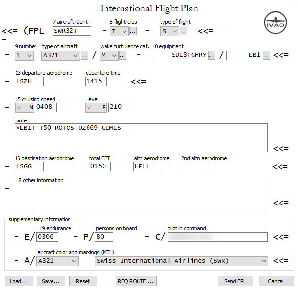
How to file a flightplan

Never filled out a flightplan before? No Problem, here you will find all you need to know.
1
2
3
4
5
6
7
8
9
10
11
12
13
14
15
16
17
18
19
20
21
1

Item 7 – aircraft identification

2

Item 8 – flightrules

3

Item 8 – type of flight

4

Item 9 – number

5

Item 9 – type of aircraft

6

Item 9 – wake turbulence category

7

Item 10 – equipment

8

Item 10 – equipment

9

Item 13 – departure aerodrome

10

Item 13 – departure time in UTC

11

Item 15 – cruising speed

12

Item 15 – cruising level

13

Item 15 – route

14

Item 16 – destination aerodrome

15

Item 16 – total EET

16

Item 16 – alternate aerodrome

17

Item 18 – other information (only official remarks)

18

Item 19 – endurance

19

Item 19 – persons on board

20

Item 19 – pilot in command

21

Item 19 – aircraft color and markings (mtl)

Items

One of the following is valid:

  • registration mark of the aircraft without dashes (e.g. HBTVZ)
  • ICAO designator of the company operating the aircraft followed by flight number (e.g. EZS402G)
  • military callsign as requested by domestic authorities (e.g. SUI107)

This letter describes the categories of flight rules :

  • I : IFR – It means that the whole flight will be done under Instrument Flight Rules
  • V : VFR – It means that the whole flight will be done under Visual Flight Rules (which assumes Visual Meteorological Conditions)
  • Y : IFR > VFR – It means that the flight will be initially IFR followed by one or more subsequent flight rules changes
  • Z : VFR > IFR – It means that the flight will be VFR first with any number of subsequent changes.

When a “Y” or a “Z” flight is prepared, “VFR” or “IFR” must be entered in the route string wherever the transitions/changes to the flight rules are planned to occur.

  • S if scheduled flight (commercial flight following a time-table)
  • N if non-scheduled flight (occasional commercial flight)
  • G if General Aviation (non-commercial flight)
  • M if Military
  • X if other than categories above (e.g. Search And Rescue, etc.)

Number of aircraft if greater than one

ICAO designator according to manufacturer and aircraft model (e.g. A319, C172, etc.)

Assign the correct wake turbulence according to Maximum Take-Off Weight (MTOW). Please note, the wake turbulence does not change in base of current load of aircraft.

  • L if Light – MTOW of 7,000 kilograms (15,000 lb) or less
  • M if Medium – MTOW of greater than 7,000 kilograms, but less than 136,000 kilograms (300,000 lb)
  • H if Heavy – MTOW of 136,000 kilograms (300,000 lb) or greater

Radio Communication , Navigation and Approach Aid equipment.

Preceding the oblique stroke, insert one letter as follows :

  • N : if no equipment for the route to be flown is carried, or the equipment is unserviceable.
  • S : if standard COM/NAV equipment for the route to be flown is carried and serviceable.

and/or one or more of the following letters to indicate the COM/NAV equipment available and serviceable :

  • A : LORAN A
  • C : LORAN C
  • D : DME
  • E : EGWPS
  • F : Not implemented yet
  • G : GPS /GNSS
  • H : HF RTF
  • I : INS (Inertial navigation)
  • J : Data link
  • K : MLS
  • L : Not implemented yet
  • M : Omega
  • O : Not implemented yet
  • P : Doppler
  • R : RNAV (RNP/RNPC)
  • T :TACAN
  • U : UHF RTF
  • V : Not implemented yet
  • W : RVSM
  • X : MNPS
  • Y : CMNPS
  • Z : if other equipment ; specify in item other information, preceding by COM/ or NAV/

Insert one of the following to describe the serviceable SSR equipment carried :

  • N – Nil
  • A – Transponder – mode A – 4096 code’s
  • C – Transponder – mode A – 4096 code’s and mode C
  • X – Transponder – mode S – without pressure altitude and without aircraft identification transmission
  • P – Transponder – mode S – with pressure altitude but without aircraft identification transmission
  • I – Transponder – mode S – without pressure altitude but with aircraft identification transmission
  • S – Transponder – mode S – with both pressure and aircraft identification transmission

In alternative, based on the latest SSR equipment the following code are available (and usable):

  • N – no surveillance equipment is carried for the route to be flown, or is unserviceable
  • A – Mode A
  • C – Mode A and Mode C
  • E – Mode S with aircraft id, pressure altitude and extended squitter (ADS-B) capability
  • H – Mode S with aircraft id, pressure altitude and enhanced surveillance capability
  • I – Mode S with aircraft id, but no pressure altitude capability
  • L – Mode S with aircraft id, pressure altitude and extended squitter (ADS-B) and enhanced surveillance capability
  • P – Mode S, including pressure-altitude transmission, but no aircraft id capability
  • S – Mode S, including both pressure-altitude and aircraft id capability
  • X – Mode S without both aircraft id and pressure altitude capability

ADS capability requires further explanation of equipment on board and code is put next to SSR equipment code (e.g. LB1, LB2):

  • B1 – ADS-B with dedicated 1090 MHz ADS-B out capability
  • B2 – ADS-B with dedicated 1090 MHz ADS-B out and in capability
  • U1 – ADS-B out capability using UAT
  • U2 – ADS-B out and in capability using UAT
  • V1 – ADS-B out capability using VDL Mode 4
  • V2 – ADS-B out and in capability using VDL Mode 4
  • D1 – ADS-C with FANS 1/A capabilities
  • G1 – ADS-C with ATN capabilities

ICAO of the airport from which the flight will start. If no ICAO designator is available, use ZZZZ, and insert name in field 18. with prefix DEP/

Estimated off-block time (time of push-back or taxi out) in UTC (e.g. 0800, 1825)

Insert the True Airspeed (TAS) of the flight, or first part of the flight (as requested by authorities):

  • N if Knots (e.g. N0477)
  • M if Mach Number (e.g. M084)
  • K if Kilometres per hour (e.g. K0350)

Cruising level or altitude in one of the following formats (as requested by authorities):

  • F if Flight Level (e.g. F090, F330)
  • A if Altitude in hundreds of feet (e.g. A025, A170)
  • S if Standard Metric level in tens of metres (e.g. S1130)
  • M if tens of Metres (e.g. M8040)
  • VFR for VFR flight in which there is no specific altitude to maintain

Full route followed including change of flight rules if Y or Z, altitude and speed.

IFR-Route example
VEBIT T50 ROTOS UZ669 ULMES

Y-Route example
VEBIT T50 ROTOS VFR Fribourg Lausanne Nyon

Z-Route example
Nyon Lausanne Fribourg IFR ROTOS T50 VEBIT

VFR-Route example
Bremgarten WIL Bern Fribourg Lausanne Nyon

ICAO of the airport to which the flight will end. If no ICAO designator is available, use ZZZZ, and insert name in field 18. with prefix DEST/

Estimated En-route Time in hours and minutes (e.g. 0050, 0730)

ICAO of the airport used as alternate. If no ICAO designator is available, use ZZZZ, and insert name in field 18. with prefix ALTN/

Insert 0 ( zero ) if no other information, or, any other necessary information in the preferred sequence shown below, in the form of an appropriate indicator followed by an oblique stroke and the information to be recorded.

  • ALTN/ destination alternate aerodrome if the letter group „ZZZZ“ is inserted in Item 16
  • AWR/Rn Alternative flight plan on the basis of the Aircraft Operator „What-If“ Re-route Function (AOWIR), whereby „n“ designates the current number of the AOWIR alternative flight plan
  • CODE/ Aircraft address (expressed in the form of an alphanumerical code of six hexadecimal characters) when required by the appropriate ATS authority
  • COM/ indication of radio telephony equipment carried if letter „Z“ is indicated in Item 10
  • DAT/ Data related to data link; followed by the letters S (for satellite), H (for HF), V (for VHF), and/or M (for SSR Mode S)
  • DEP/ departure aerodrome if the letter group „ZZZZ“ is inserted in Item 13 or the point from which the flight plan is applicable, or the position from which supplementary flight plan data may be obtained if the letter group „AFIL“ is inserted in Item 13
  • DEST/ destination aerodrome if the letter group „ZZZZ“ is inserted in Item 16, or the point to which the flight plan is applicable
  • DOF/ Date of flight, given in the sequence year-month-day
  • EET/ significant points, points with change of flight rules, indication of locations or FIR boundaries with accumulated estimated elapsed time
    Example: EET/KONSTANZ0050 
  • MDCN/ Military Diplomatic Clearance Number; for military aircraft
  • NAV/ indication about the radio navigation equipment carried if the letter „Z“ is indicated in Item 10
  • OPR/ aircraft operator, if not obvious from the aircraft identification in Item 7 of the flight plan form
  • PBN/ required when R equipment on board for description of RNAV equipment
  • PER/ aircraft performance data (e.g. rate of climb)
  • RALT/ name of enroute alternate aerodromes
  • REG/ aircraft identification
  • RFP/Qn replacement flight plan (replacement, alternative flight plan), „n“ indicating the current number 1 – 9 of the replacement flight plan for the flight concerned
  • RIF/ changes of routing to the changed destination aerodrome and/or changed destination aerodrome
  • RMK/ any other remark significant for the handling of the flight by ATS
  • RVR/ RWY visual range (in metres)
  • SEL/ SELCAL Code
  • TYP/ type of aircraft if the letter group „ZZZZ“ is inserted in Item 9
  • STS/ Reasons for special handling:

STS/ATFM EXEMPT APPROVED*

STS/EMER Flights engaged in emergency missions (***)

STS/EXM833 State aircraft, not equipped with 8.33 kHz channel spacing radio equipment prescribed for an area

STS/HEAD Flights with Heads of States*

STS/HOSP Flights with sick or injured persons needing immediate medical assistance, including flights urgently required for life-saving medical care of sick or injured persons. This comprises both flights for the transport of transplants, stored blood and medicine and flights to be conducted to pick up a patient, transplants, stored blood or medicine at the destination place.

STS/HUM Flights operating for humanitarian reasons

STS/NIL Replaces all other STS/entries. Only to be used when reporting flight plan changes.

STS/NONRNAV State aircraft, not equipped with type RNP prescribed for a route segment, a routing and/or an area

STS/NONRVSM State aircraft without RVSM permission.

STS/PROTECTED Flights critical to safety, the flight plan of which is only to be made available to a limited circle of recipients.

STS/RNAVINOP For aircraft, the RNAV equipment of which is inoperable at short notice or no longer complies with the required minimum conditions

STS/SAR Flights engaged in Search and Rescue missions (***)

STS/STATE Government flights

(***) Leads to an automatic exemption from ATFM restrictions.

Total fuel endurance in hours and minutes (e.g. 0145, 0940)

Insert total people on board of the plane (passengers and crew). If the total number is unknown at the moment of filing, insert TBN (i.e. To Be Notified)

Name of the Pilot In Command (PIC)

IVAO
Insert aircraft type you wish other pilots and controllers see you with (when available, if not you can choose similar one), and texture with significant marking.

Real flightplan
Insert the color of the aircraft. This is important for search and rescue-reasons.
Example: White with blue stripes